

Attempted, Attempted and Attempted Again to find that Confounded Tube.
Attempted, Attempted and Attempted Again to find that Confounded Tube.
Mojave National Preserve Adventure

National Park Service Pass
Last June, I became aware of the savvy investment of purchasing a National Park Service (NPS) pass for $80 granting purchasers free entry into the United States National Parks for a year. Highly recommend purchasing it if planning on visiting at least 3 of our beautiful National Parks in a twelve month period. Otherwise you’re looking at about $30 per entry. That being said, my standard is to determine which National Parks are near my latest travel nurse assignment to make good use out of my eighty bucks.
During my assignment in Burbank, California, my first bucket list park adventure was Joshua Tree National Park. A journey I detailed in a previous story titled "Sunrise at Joshua Tree." Feel free to check it out. It was a truly unforgettable experience and pushed me beyond my personal boundaries in many ways. You’ll see in this story, I’ve done it again with achieving success on personal boundaries.
MOJAVE DESERT vs. MOJAVE NATIONAL PRESERVE
While still on assignment in Burbank, I was fortunate enough to be able to move on to visit a second park while there. Found Mojave desert as an option and Death Valley. Both were about a 2-4 hour drive time from my location in North Hollywood. I was feeling more Mojave and less Death. Mojave it is. I had questions though. Historically I’ve only heard of Mojave desert. The place on the map was referred to as Mojave National Preserve. What is the difference you ask? I wanted to know as well.
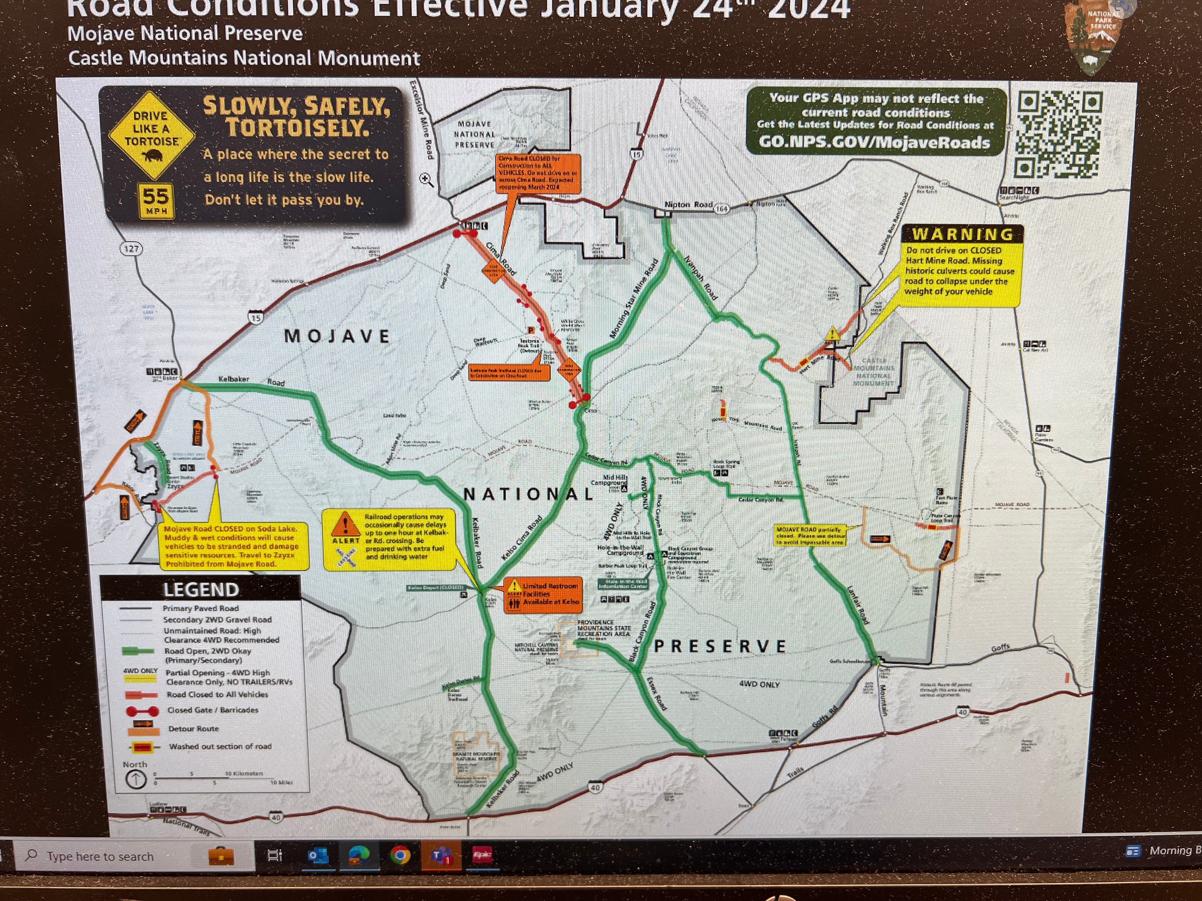
After a bit of Googling, I found that the Mojave Desert is a geographical region covering parts of California, Nevada, Utah, and Arizona. On the other hand, the Mojave National Preserve (map from NPS app below) is a designated national park unit within the Mojave Desert, managed by the National Park Service. Ok, that explained it and met my now imperative desire to step foot into the Mojave desert.
PLANNING MY ADVENTURE
I reviewed the Mojave National Preserve map above. Second to time constraints on the day trip aspect of this excursion, I felt I could visit the “Lava Tube” and then hike “Rings Loop”. Once those two tasks were completed I would have adequate time to return home at a reasonable time. I’d hit the lava tube initially as that was listed as a thirty minute timeframe expectation so I could get that out of the way prior to my hike.
Typical hiking attire, snacks, water and fuel accomplished. Expected a 2-3 hour drive with goal to head into the park off Route 15 on to Kelbaker Road (left upper entrance on map). Downloaded the “off line” version of this map from the NPS app on my phone (lesson learned from The Joshua Tree trip). Pulled off the freeway and decided to stop at the gas station to fill up again prior to officially entering the park. It is the desert after all.
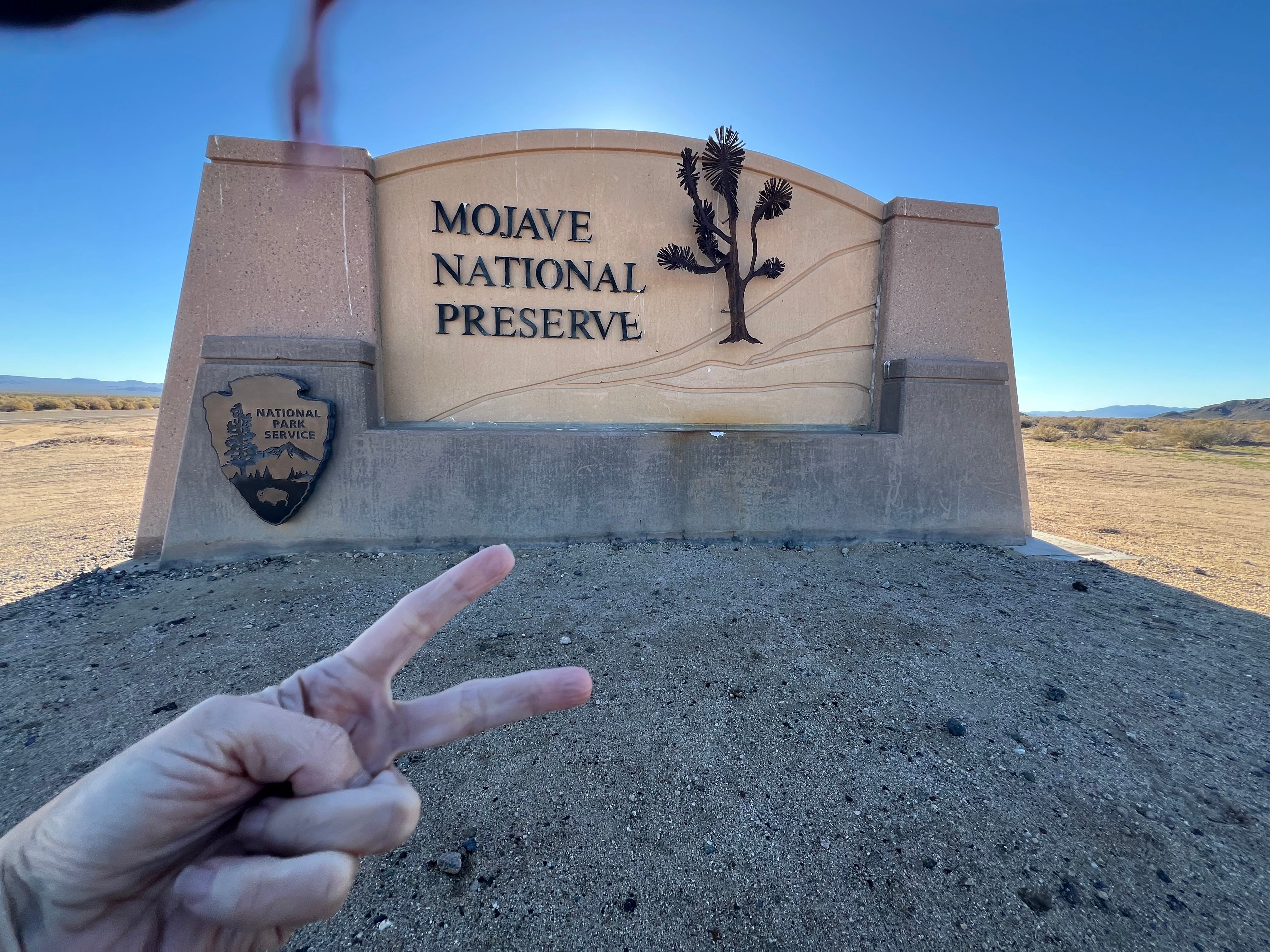
Drove into the park. Had my NPS park pass ready to show the representative in the booth. Never came upon a booth, but drove up to this beautiful signage. “I made it to the park without a glitch!”
LET’S FIND THAT LAVA TUBE
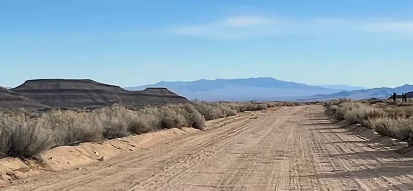
I was driving my Mazda 2 wheel drive CX-30 named Blue Velvet. She and I were enjoying the ride in the desert and were jamming out to Spotify as usual. After about 20 miles of driving through said desert, I thought “Damn this is taking a minute. All this time and I’ve only passed by 6-10 other cars and they were going in the opposite direction. It is truly desolate out here.”
Shortly after that thought, I saw a left turn which was supposed to lure me directly to the lava tube location. I took the turn and pulled over to review my “naviguesser” tools. Directions on my functioning GPS indicated to I should park in a circular appearing lot and then walk a short distance to get to the lava tube trail. GPS also reflected a blue dot indicating I was near my destination. I don’t see a truly circular lot, but the blue dot seems more official. I grabbed my gear and started walking toward the blue dot reflected in my GPS. After about a 1/4 mile jaunt through the desert, my GPS showed that I had passed the blue dot. Yes, I then tried going north, south and west of that flipping blue dot and kept passing it on my phone screen. I did not see the anticipated railed stairs to enter the downward path into the tube. I did not see a sign to highlight where I’d wandered to. What I did see during this unproductive walking adventure, was that turning around to attempt to visualize Blue Velvet was not easy in the desert. She disappeared from my sight briskly. Not an appealing discovery.
During the aforementioned walking attempts, a fella in a gray Range Rover pulled over and inquired if I was “okay”. He had 2 other vehicles following him and they pulled over as well. Relayed that I was fine. Shared what I was attempting to find and he was unsure of where it was, but asked “why don’t you drive?” I shared what my phone was showing me, those blue dots, but did not wish to go into a lot of detail. I did explain that I have never felt this inept geographically. Left it at that and thanked him for his kindness. I watched the three vehicles take off with the dust debris from the dirt road flowing through the air.
I started walking back to my car thinking of our conversation about driving. I was concerned about taking my 2WD Mazda down that particular road as it was recommended on the map to use 4WD. The man in the Range Rover did say a “hybrid compact car can make it down that road, just go slow.” Trust but verify, Michelle. I made it back to the car in one piece and started the drive.
The dirt road had intermittent holes, rocks and was described on the GPS as washboard driving. I had no idea what washboard driving meant. Once I started driving and felt and sort of heard a constant bam, bam, bam, bam, I realized I’d experienced it before but never knew the name. I had to drive extremely slowly to manage that type of bumpy terrain. While doing that, I was pleased to learn that my cell phone worked for calls at that time in the desert because I received a call from a neighbor from home. Perfect timing since I had to drive so slowly. I could be distracted. We chatted about 40 minutes until I reached around 4 miles. At that point, there was a Y in the road without signage. I needed to focus on my driving and ended the call. I proverbially rolled the dice and took a right in the Y for another half mile until I threw in the towel and turned around. It just didn’t feel correct. Getting agitated at that point. “I have a master’s degree and I’m unable to find something on a map along with the addition of technology? What am I missing about those blue dots. ARGH!”
On my way back I needed to share my frustration and feelings of incompetence with someone. I was able to phone my sister and share this debacle and have some giggles about it. I attempted to visually show her what the desert looked like with the phone but FaceTime didn’t work in the desert. I was ready to hang up at that time due to a sudden recurrence of technology dissatisfaction. I continued the slow drive on the dirt laden washboard road.
"Wait. When I was driving by this area last time, I saw a human atop one of those lovely mountains and there happens to be a circular parking lot. Maybe this is the place?” As I pulled into the parking area, amazingly, there was another SUV coming in behind me. I was happy to see others at that point. I parked and walked towards them. Lovely group of 4 who were also seeking the same tube as I was. Go figure!
We discussed, speculated and reviewed their paper map (I know what you’re thinking. Michelle, you should have had a paper map, however they were unable to find it with that either). They had a 4WD vehicle and one of the fellas was seemingly confident that we would need to take the road to the right on the inside of the parking circle we were currently in. He lead the way. I started following.
This road, or should I refer to it as a pathway, included a heck of a lot of larger rocks than the familiar dirt road before. Larger holes and was super narrow. It was way out of Blue Velvets’ capacity to manage. I pulled over to the left to initiate a turn around. Waved goodbye to my new friends as they continued to drive forward.
When I pulled over, I thought I saw a stairway with rails in the distance. Got out to investigate. Maybe we were in the correct area. Walked about a 1/4 mile (huh, noticing a trend here with 1/4 mile. At least I’m getting some steps in). Realized it was not what I was hoping it would be and decided to start walking back to the car. Thinking, “why the heck did you think that thing was a railing? Is hallucination going to occur next since you’re in the desert? Laughed at myself and kept on walking. More thoughts, “I can’t see Blue Velvet. We’ve already learned that she won’t be visible until you’re almost ready to get into the drivers seat. No need to panic as panic is nobody’s friend. Continue walking Michelle, and oh, there she is, pfewwwwww.”
Got in and sat for a minute and continued thinking about this potentially turning into a missed tourist opportunity. Asked myself “Ready to get the hell out of here or give it one last ditch effort to find that fucking tube? I’m going to find that thing if it’s the last thing I do today! I need to return to that Y intersection and take a left. That is the only place I have not attempted yet.”
I started driving out of that circular parking lot and turned left to head down slowly on the dirt road again. I was obsessed and determined as if I was participating in a contest of some sort with a million dollars waiting in the wind or in that flipping tube!
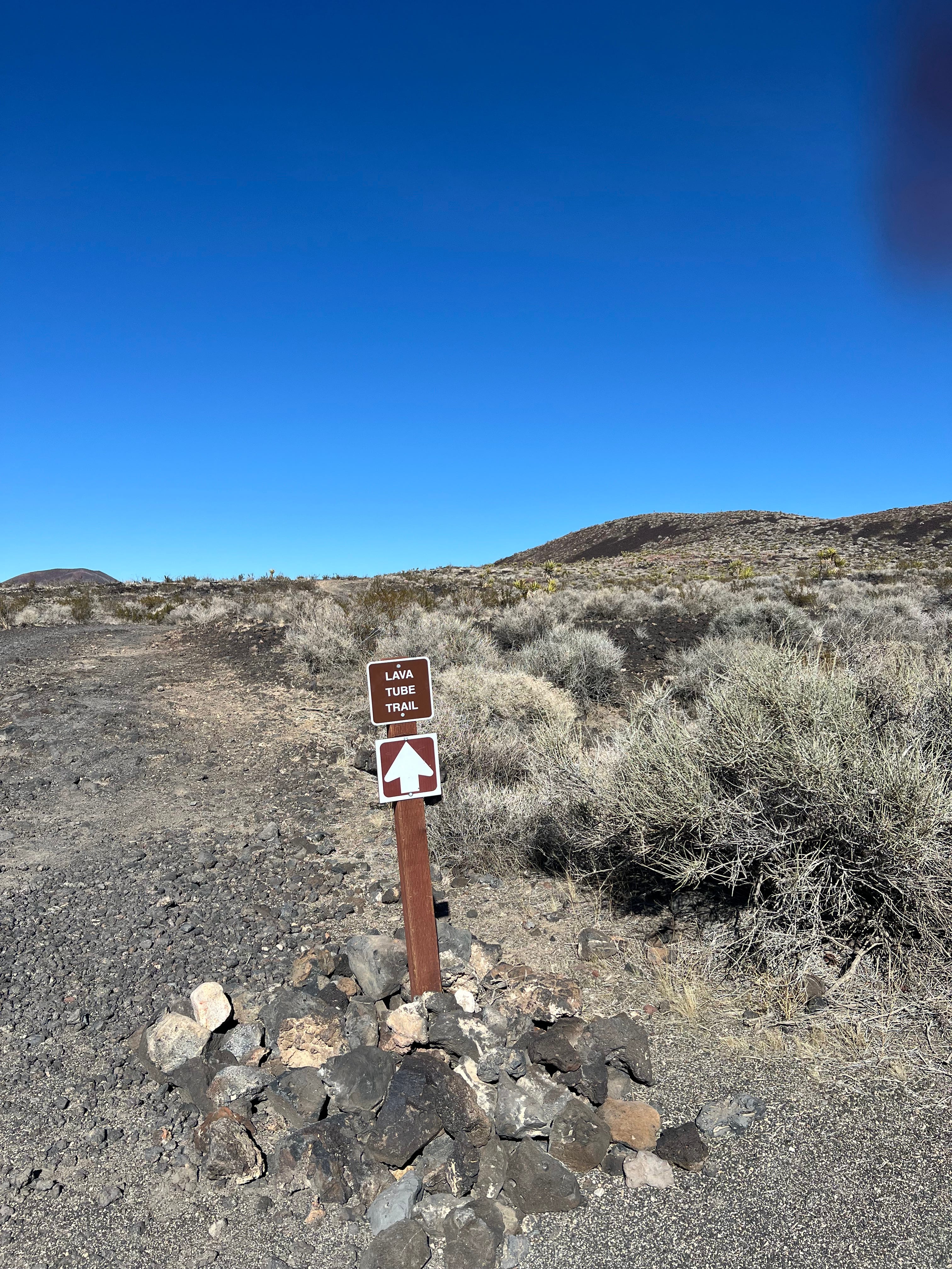
I made it to that dumb Y intersection. I took the left as planned. Continued driving for about a mile. I then passed an old decrepit fenced in area and finally came upon a sign thereafter. Imagine that, “a sign in the expansive desert indicating one is in the correct or incorrect area of their preference.” My sarcasm was at its height now in my head. I saw yet another left ahead which appeared to have a circular parking area and I saw a human on top of a hill. “Wait, I see 3 vehicles there! What in the world? Could this be true? The Led Zeppelin song lyric playing non-stop in my brain today has paid off. I found that “confounded bridge” except it was the confounded tube. Hell yeah, finally!”
I checked the sign and it was indeed the correct place “Lava Tube Trail”. I walked up the short path to the top of the hill. Viewed another sign indicating I’d arrived at my destination. Then I saw the rails on the hill. There they were, in all their glory!
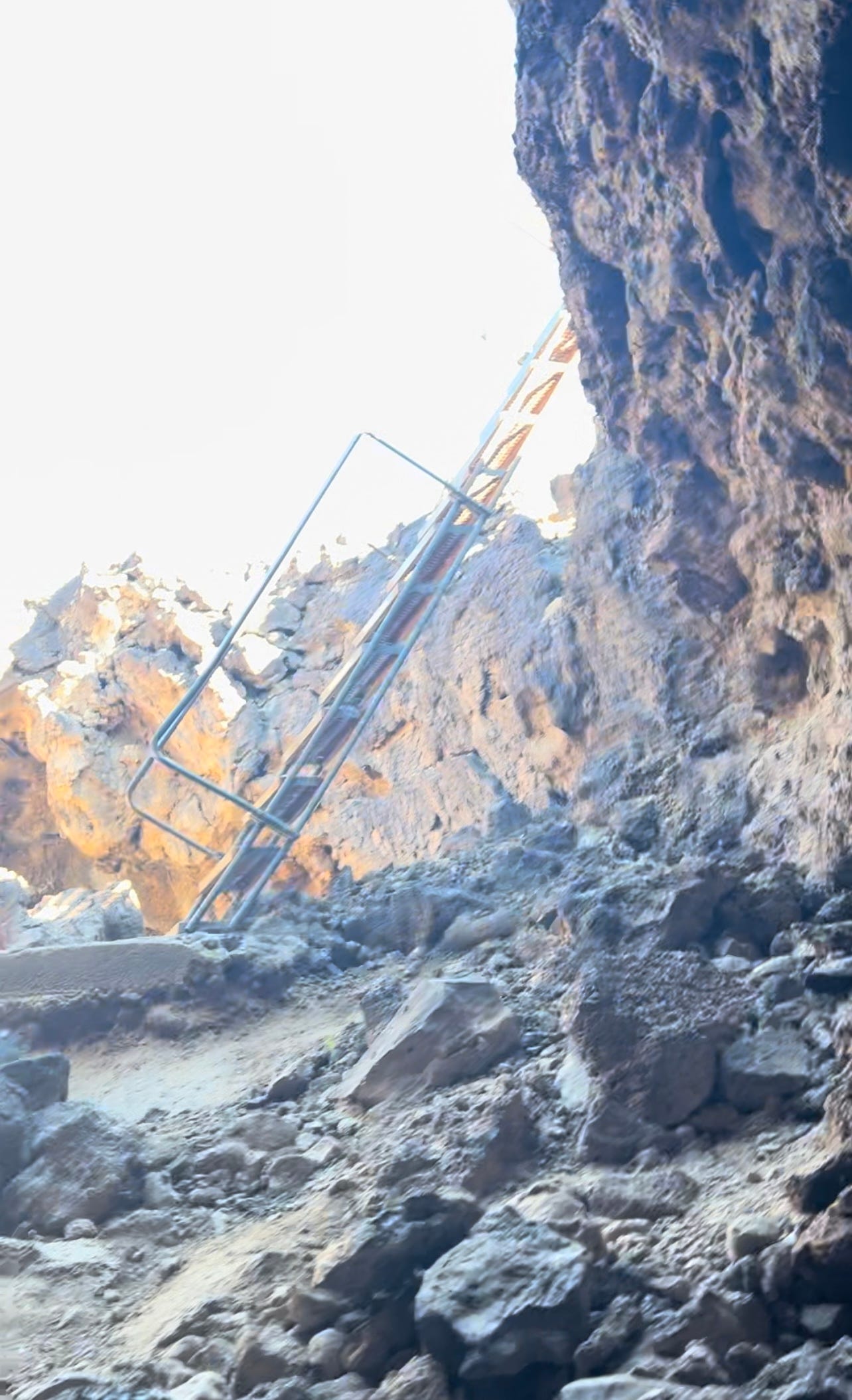
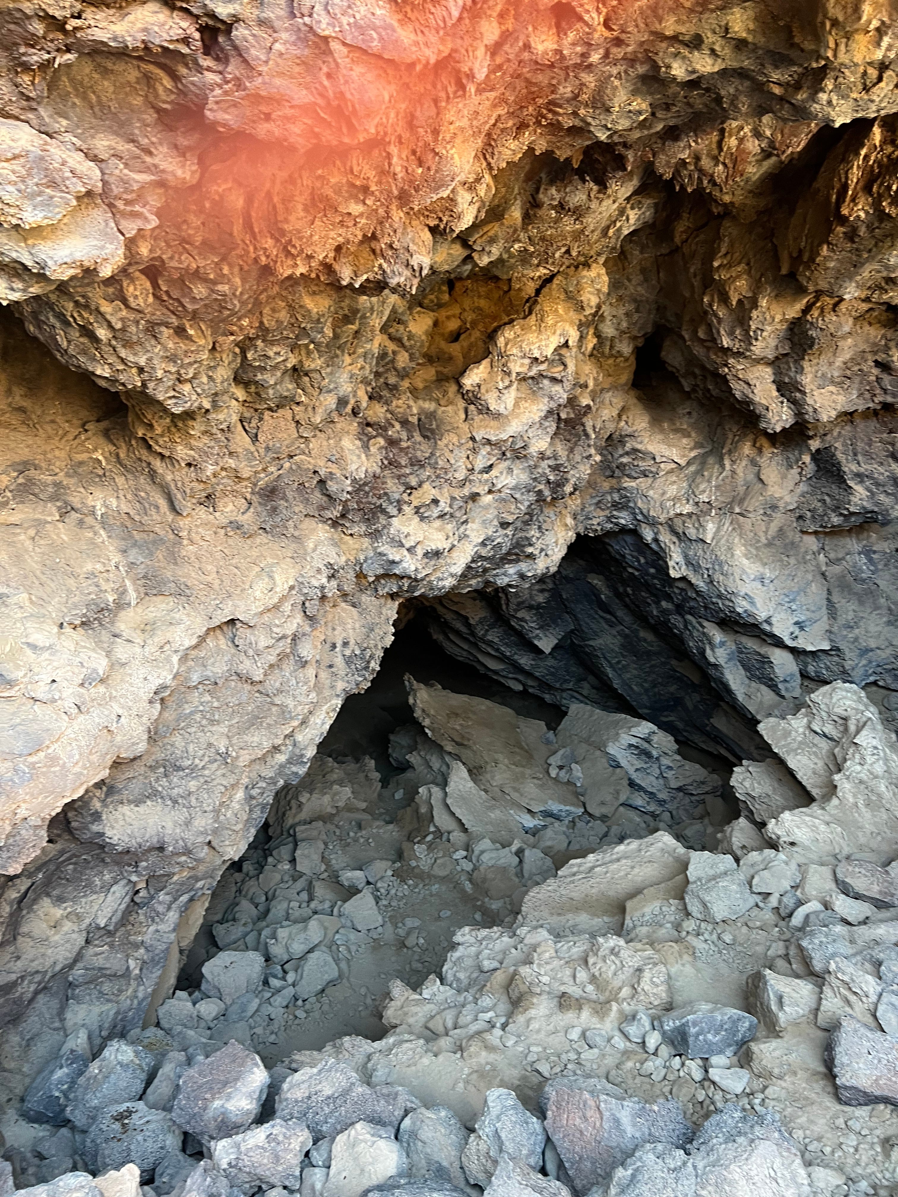
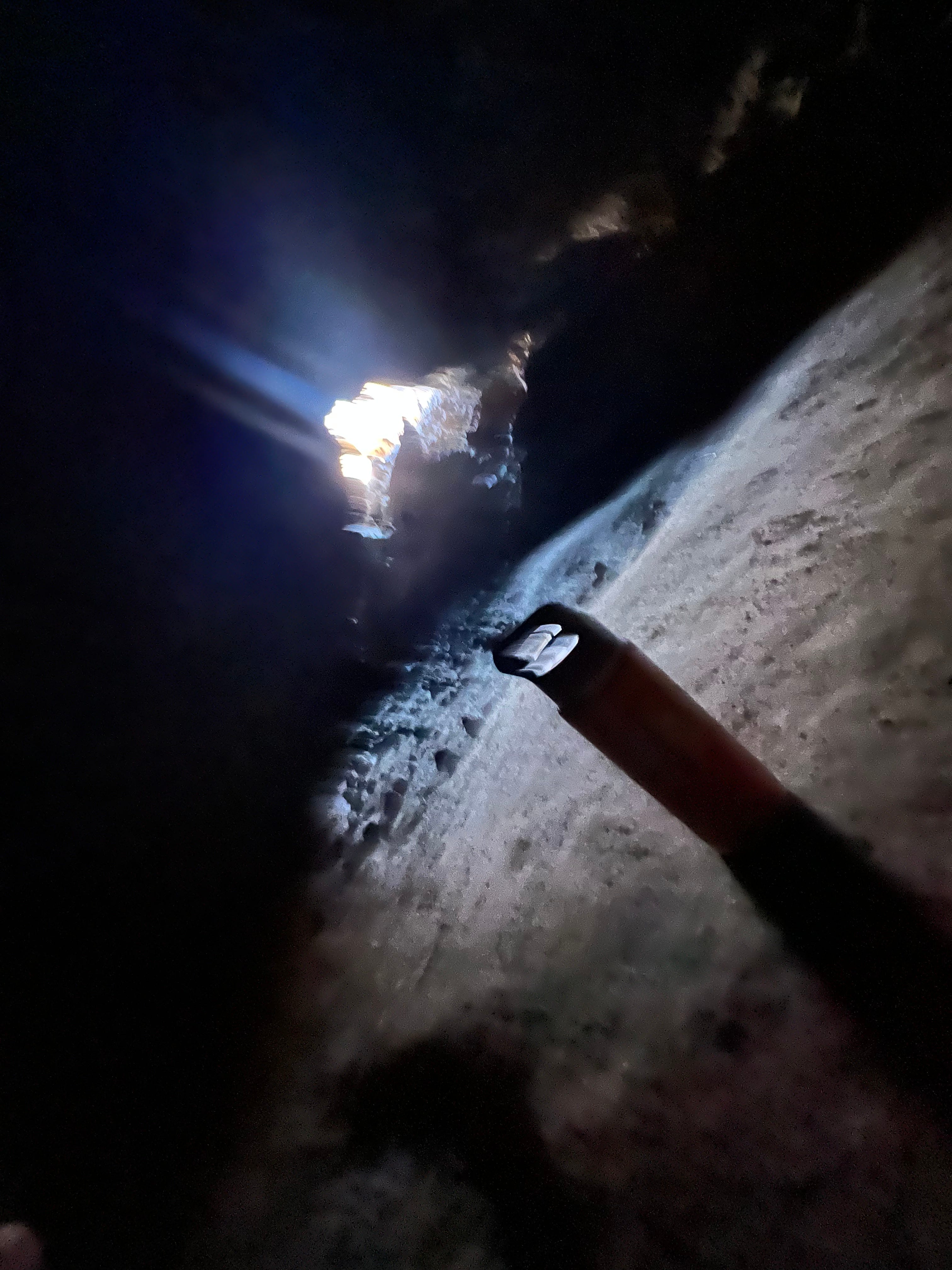
GPS did not fib about it only taking about a half an hour to walk that hill, climb down the stairs, squat through the cave opening and proceed to see the gorgeous sunlight shining through the holes above. You can see my Yeti container in the picture. I was fortunate to have brought that with me. It not only provided my hydration, but the holder on the top also allowed it to act as a miniature cane to help me get through that cave entrance. It was tight!
While I was not pleased with the amount of time, effort, and skill set required for me to arrive to that lava tube, I was and still am so happy to have been able to finally visualize, touch, and climb into this beautiful natural volcanic lava creation. So worth it!
LESSONS LEARNED THIS EXCURSION
There is not an entrance fee for the Mojave National Preserve; Have at it again for free
Continue to always fill up the gas tank just before going into any National Park. Especially this one as it is massive and extremely desolate
What about the hike you ask? I did not get to hike Rings Loop. I accepted it as “Everything Happens for a Reason”. With the luck I was having that day, I would have likely needed to be air lifted out of the desert
GPS is technology, never 100% accurate; great reminder
That was quite an adventure you had, Michelle! Perseverance paid off in the end. Great story